Hot off the press, the Second Edition of the Uwharrie Lakes Region Trail Guide features a new format for the elevation profiles. Each trail and trip in the guide has its own detailed graph to help you visualize the elevation changes and important locations along the length of the route.
 The previous edition of the guide contained elevation profiles that were a simple plot of elevation vs distance. A mileage table with text descriptions for key spots along the route was shown above the profiles.
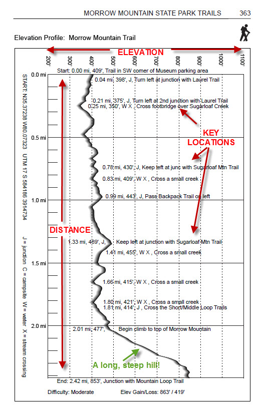
The new elevation profiles are a mash-up of the plots and the mileage tables. Each profile starts as a simple plot of elevation vs distance, and then the text descriptions are laid on top of them. The text descriptions are placed on the plot at the appropriate mileage point.
One advantage of this new design is that the profile graph can now be enlarged to fill the entire page, making it larger and easier to see. The descriptions are accurately placed along the route, so you can easily see if your next turn is close by or much further down the trail.
Each profile graph for trails or trips in the same area shares the same elevation scale so you can easily see relative elevation differences between trails. For example, all of the profiles for Morrow Mountain State Park have an elevation range of 200 feet to 1,100 feet. The Three Rivers Trail appears low on its graph, which is logical since it starts near the boat ramp on Lake Tillery. The Morrow Mountain Loop Trail appears high on its graph, since it circles the summit of Morrow Mountain.
The text descriptions for key spots include the mileage along the trail and the actual elevation in feet. Simple codes in the description indicate if the spot is an intersection, a stream crossing, a water source, and/or a campsite. The names of intersecting trails are also given. A legend for these codes is on the side of each profile, along with GPS coordinates (both Lat/Long and UTM) for the “start” of the trail (in case you need help getting back!)
Each profile page contains a wealth of information for the trail visitor. The profiles might seem a little confusing at first glance, but once you learn how to read them, you will appreciate how much helpful information one page can give you! If you don’t have a copy of the new Uwharrie Lakes Region Trail Guide, order one today!