Road Trip!!!
A road trip is a great way to get out and enjoy seeing the world. Destination trips can be fun too but for sheer volume of scenery, it's hard to beat a road trip. You can travel by bicycle, motorcycle, car, or RV. All it takes to get a road trip started is to say to yourself "I'd like to go see ____."
I was fortunate enough to take a long road trip this summer and would love to tell you all about it. But don’t worry. I'm not going to make you click through a tortuously long vacation pics slideshow! I will share some of the pictures and details in future blog posts.
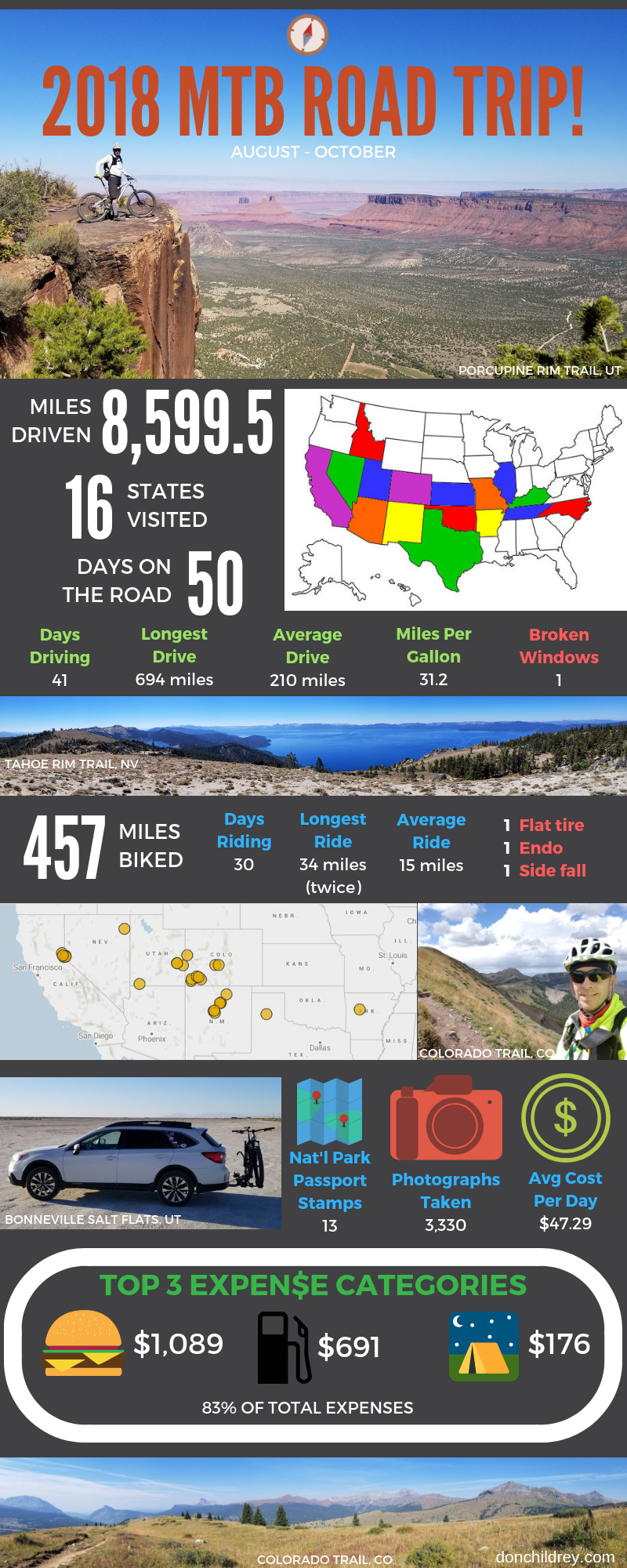
To make a long story short, I loaded my mountain bike on the back of my car and drove across the country, from North Carolina to California and back. Here's a fun little infographic summarizing how my trip went:
This was definitely a big trip, my longest so far, so please don't be intimidated by it. The point is to inspire you to think about some places you would like to see. Write several of them down in a list and just start thinking about how you could make a road trip happen. Starting the thought process is the key to turning your trip dreams into reality!
Will you change your plan dozens of times before it's all over? I certainly did! That is a normal part of the process. My departure date and general route were set by a few specific meet-ups with friends and family but I left plenty of room for flexibility in my plans, and in my expectations. Some of my best traveling friends and I are fond of saying "the adventure doesn’t start until the plan gets thrown out the window!" The trick is to have a set of tools and attitude that will let you quickly adapt and adjust your plans on the fly.
Planning Tools
What tools can you use to plan a road trip? I started with a simple spreadsheet, laid out with a row for each day. I used LibreOffice Calc, but Microsoft Excel or any other spreadsheet tool would work. You could also do this on paper, but leave room for making changes! I labeled one of the columns to hold where I planned to spend that night. Planned mileage for the day would go into another column. Points of interest would go in another column. The spreadsheet format gave me a framework to fill in as my plans developed. The grid kept things organized and was easy to expand.
From my experience with past trips, I knew I wanted to keep my daily driving mileage under 250 miles, if possible. I have a tendency to focus on more interesting destinations and pass by seemingly lesser ones. That can result in some high-mileage days. Your preferred daily mileage will likely be different, but having a number in mind helps you determine where you will need to spend each night.
Where to Stay
Using the My Maps tool within Google Maps, you can create your own custom map with markers for places you choose. These markers are visible regardless of what zoom level you're at, which makes it easier to see the 'big picture'. For example, I put markers on the map for each of my friends and family who lived along my general route. I could easily see if any of them were conveniently located near where I needed to spend a night. If not, I would need to search for other overnight options in those areas.
One of my goals was to travel frugally. Camping or staying with friends or family instead of staying in hotels will help keep costs down. The Free Campsites website was very helpful for finding places to camp with little to no cost. The more self-contained or self-reliant you are, the more options you'll have. Camp locations I found through this website ranged from simple pull-offs on a dirt Forest Service road to BLM sites with brand new metal picnic shelters, tables, and grills beside a trout stream. Campendium is another site that lists free and other camping options.
Free campsites usually don't allow reservations and come with a bit of uncertainty, so it's a good idea to identify a nearby alternative or two. Just in case you get there and it's occupied or you just don't like the spot for some reason.
I eventually figured out how to arrange my stuff and sleep comfortably in my vehicle. Being able to 'camp' inside my vehicle opened up even more possibilities for free places to spend a night. You can't pitch a tent in a Walmart parking lot, but if you park your vehicle close to the RV's and tractor-trailers that are overnighting there, it is possible to spend the night without being run off by security!
Where to play
Once you have a rough idea of where you'll stay each night, you can work on places to visit each day. I used Google Maps to look for interesting places between my overnight locations. Parks and other large recreation destinations show up easily on Google Maps. You may have to zoom in to find smaller attractions or businesses.
Another goal of mine was to mountain bike in new places. The MTB Project website and app was handy for finding bike trails. This tool is sponsored by REI. Trails are added by users and vetted by staff and trained volunteers. You can visually search on a map for an area you'll be visiting. If you see any trails you like, you can add them to a 'Trail To-Do List'. Once you're at the trail, the app will use your phone's GPS (no cell signal required) and show your exact location on the map. The app doesn't offer turn-by-turn navigation, but knowing where you are on the map is pretty darn helpful.
While I was in Tahoe City, I talked to some local riders about where to ride. The guys at the local bike shop also helped me out with maps and suggestions. The locals also told me about the Trailforks website and app. It is very similar to MTB Project but is sponsored by PinkBike. Trailforks had more trails listed in the Western states, at least for the area around Lake Tahoe. Like MTB Project, the Trailforks app also shows your location on the map.
I used the Hiking Project app (sister site to MTB Project) when I hiked trails in a few of the National Parks I visited.
The Avenza Maps app came in handy for some of the places I visited. This app displays georeferenced PDF files from their Map Store or that you upload to the app yourself. The app will show your exact location on the map. You can also record tracks or waypoints within the app.
The Avenza Map Store has many free maps, such as maps of individual National Parks, or a whole-country map showing all of the Park locations. You can also load custom georeferenced PDF maps from other sources, such as the CalTopo website. I created a few maps using CalTopo that showed our planned campsites along the Colorado Trail.
In the Avenza Map Store, I found free MVUM maps for the National Forest Districts along the Colorado Trail. MVUM stands for 'motor vehicle use map.' These maps show all of the Forest Service roads that are open to the public. These maps helped guide our support truck driver to our campsites along the Colorado Trail each night. Having our food and camping gear show up was very important!
I also picked up paper highway maps in each of the states I visited, but I never had to use these for navigation. Most of the time the navigation system in my car or on my phone got me where I needed to go.
When to stay put
Since I spent so much time outdoors, knowing about incoming weather was helpful. Personally, I like to see radar in motion and draw my own conclusions about whether I'm about to get rained on or not. The MyRadar app works pretty well for me. It quickly displays a zoomable map with overlays showing precipitation, weather warnings, wildfire locations, and more. You can easily drag the crosshairs to another location on the map and get basic weather data for that spot.
I used other smart phone apps now and then, including all the social media apps for sharing your adventures with others. As I traveled further away from convenient wifi and even cell coverage (and closer to my data limit) I found that my social media posts slacked off. I'll call that 'living in the moment'.
What apps or tools have you found useful for planning a trip? Please leave a comment below.
November 28, 2018
Most States have a “State Park app” and I download these when we road trip. I can quickly find attractions that are close to me and what they have to offer as we move between our targeted destinations. We always keep a very loose schedule that allows for us to be a day late if we find something neat along the way. We check in with our “emergency contacts” often with updates because will usually only have one or maybe two destinations with a well defined arrival. Traveling in this way, we have found that many of our best adventures have been in the hidden gems we might otherwise have missed.
November 28, 2018
Great tip, Daniel! I agree, the best adventures are often unplanned!