![]()
![]()
Lost trail
The West Morris Mountain Trail was already lost by the time it appeared on a USGS quadrangle map in 1994. At that time, I was writing the first edition of the Uwharrie Lakes Region Trail Guide. I looked for the West Morris Mountain Trail as I pushed my measuring wheel along Camp Road, which leads from the hunt camp to the Uwharrie Trail.
The 1994 Lovejoy quad map showed most of Camp Road as just a foot trail - a single dashed line. But that depiction was wrong. Camp Road is a double-track dirt road that connects to two other dirt roads, not shown on the map, before dropping down to the bridge at Spencer Creek.
I doubted the mapmaker had ever walked these roads and trails. The lines on the map for Camp Road, the Uwharrie Trail (red dashed line), and the West Morris Mountain Trail were clearly just rough approximations.
In the mid-1990's, I found no sign of either end of the West Morris Mountain Trail along Camp Road. With so little faith in the accuracy of the lines on this map, and with no obvious evidence of it on the ground, I left this trail for lost and moved on.
Lost Uwharrie
Nearly a quarter of a century later, I find myself writing Lost Uwharrie, a book about the search for 'lost' points of interest in the Uwharrie National Forest. I haven't forgotten - the West Morris Mountain Trail is definitely on my list.
Several things have changed since the early 1990's that should help with the search. Advancements in technology have given us handheld GPS devices. We can now tell within 30 feet or less where we are standing on the map. It's one thing to be able to read a map and keep track of where you are, but to have a digital finger point precisely to your location on a map is like magic!
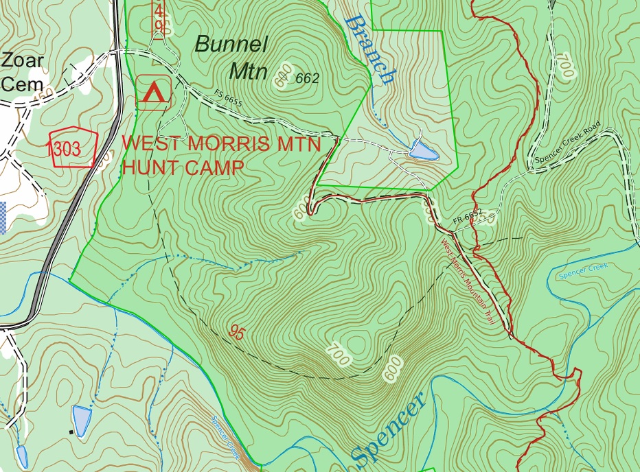
Maps and map tools are better now. Using the caltopo.com website, I combined their MapBuilder Overlay, which brings in trail and road lines from OpenStreetMap (OSM), with the USFS's 2016 FSTopo base map. The end result is the most current and complete map data I could find for this area. I exported this combined map as a geo-referenced PDF file and then imported it into the Avenza Maps app on my smartphone. Better maps through technology!
Unfortunately, the dashed line for the West Morris Mountain Trail still appears exactly as it did on the 1994 map. The east end of the dashed line is left dangling instead of connecting to anything. This U-shaped line is a Cheshire cat grin lingering on the map, mocking me like it knows I know the trail was there but I can't see it.
Armed with newer technology, a better map, a bit of inspiration, and a few more years of experience, I recently returned to look for the West Morris Mountain Trail.

This trip was my first field trial of some new trail shoes - Keen Voyageur Hiking Shoes. I have been looking for a lightweight hiking shoe with a stiff insole for better protection from a day of stepping on uneven ground, jagged rocks, etc. I also wanted a shoe with less mesh ventilation directly over the toes, where dust and small particles often fall in. The Voyageurs seem to meet these requirements. I'll report my impressions in more detail on my Recommendations page after a few more trips.
As soon as I opened my car door at the West Morris Mountain trailhead, I was greeted by a face-up penny lying on the ground. I thumbed the dirt off President Lincoln and carefully laid him on my floormat. It can't hurt to be kind to omens of good luck.
I began by walking up Camp Road to the top of the ridge. Along the way, the map and the app worked great. The line for Camp Road was right where my GPS track said I was walking, even as I passed through the hairpin turn. When I reached the junction with Morris Mountain Road (FR 6652), the app showed me at that precise spot on the map.
Continuing down the hill along Camp Road, I watched my location on the app map until I was standing where the dubious dashed line of the lost trail crossed the road. I looked around hopefully, even though I was pretty sure there would be no sign of the lost trail here.
I was not wrong. No blazes. No faint trail tread. No remnant of a long-abandoned roadbed. Nothing.
What next?
Could I get into the mapmaker’s head and guess what scraps of good information he did have, if any, when he drew the rough trail line on the 1994 map? I have used this technique successfully before when faced with orienteering and adventure race course errors. Instead of simply giving up on finding a control point, guessing how the mapmaker might have made a mistake and checking those out sometimes pays off.
At the most basic level, the mapmaker's line for the lost trail appears to tell us four things: it started near the hunt camp, swung southward around the southwest ridge of Morris Mountain, junctioned with Camp Road, and ended at the Uwharrie Trail. Can we prove any of these? So far I've failed to find the start and end of the trail. That leaves two things to dig further into.
The mapmaker drew the Camp Road line with a definite turn at the end, having it Tee into the West Morris Mountain Trail. That turn seems like a deliberate clue. He could have just drawn the two lines joining together in a simple 'Y' junction.
After making a slight 'S' bend through the saddle on the ridgeline, Camp Road runs in a pretty straight line down the spur ridge toward Spencer Creek. There are no bends in the road where it reaches the Uwharrie Trail. I was starting to lose faith in the deliberate turn as a potential clue.
But what if the mapmaker was told that one trail Tee'd into the other, and then drew the intersection backward? I feel confident the mapmaker never walked these trails. Accidentally drawing this intersection backward would be easy to do. With Camp Road being so straight, it would make more sense if the lost trail Tee'd into it. If the mapmaker did make this mistake, how could I use this information to help my search?
I walked a little further down Camp Road. After going 50 or 60 feet, I still had not seen anything unusual. The open view through the pre-leaf-out forest let me see pretty far down the spur ridge but nothing there caught my eye.
Maybe I needed to look someplace else. Someplace besides along a well-traveled trail. Any clues here would have been noticed already.
The mapmaker drew the dashed line coming to this spur ridge from the higher ridge to the southwest. The lost trail would have crossed the re-entrant between them somewhere. (Re-entrant is a term used in orienteering to describe the low area between two spur ridges. Some might call it a gully or a valley. But these are really three different things if you're trying to be specific when identifying geographic features.)
I decided to make a right turn from Camp Road and just bushwhack into the re-entrant to see what I might find.
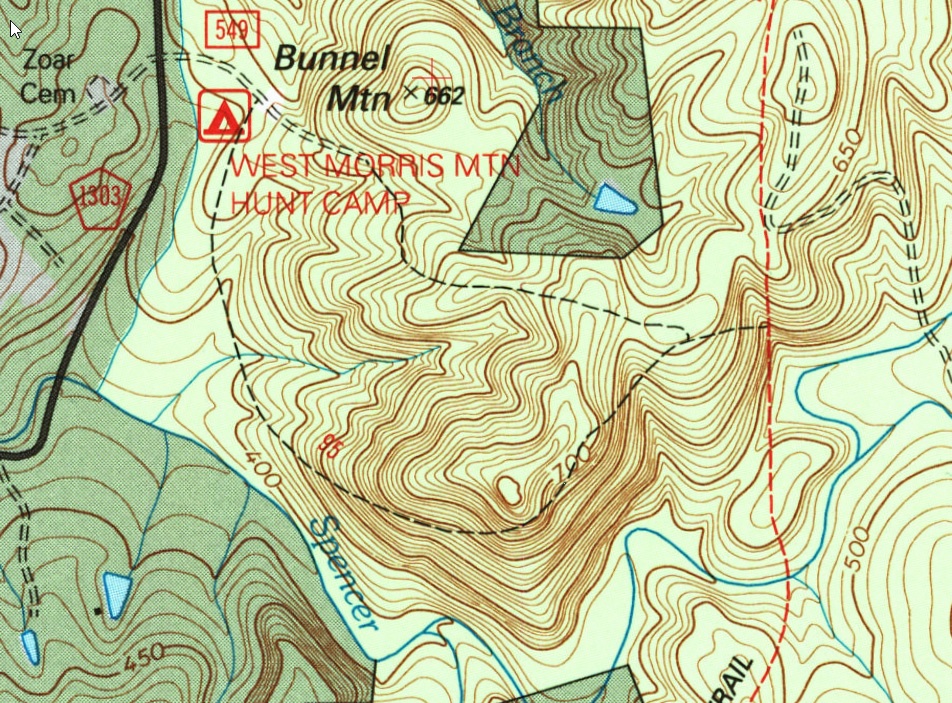
After walking about thirty feet, I could see the faint line of an old roadbed on the slope below. The old roadbed somewhat paralleled Camp Road. I suspected any evidence of the lost trail would most likely be found further up the re-entrant, closer to the saddle and the ridge to the southwest. But I decided to turn left and follow this old road downward. If it ended at Camp Road or dropped deeper into the re-entrant, I would have at least ruled out that area.
Sure enough, in about 250 feet the old road curved around the spur ridge and T'eed into Camp Road. This was a hopeful discovery. Could this be the definite turn and junction with Camp Road that the mapmaker drew backward? Maybe. If he did make this mistake, that means the lost trail ends at Camp Road, not at the Uwharrie Trail.
When I turned around and looked back, I could barely see the old roadbed I had just walked down. There was just enough brush and fallen limbs on it and not enough of a depression in the ground to make it stand out. Without knowing it was there, I would not have noticed it from this angle.
None of the trees on either side of the old roadbed showed any signs of old blazes. I headed back up to see where it led in the other direction. At least I would have a GPS track of this old road when I was done.
Once I passed the point where I first reached the old roadbed, the sidehill cut work done on this section made the roadbed more visible. Walking along slowly, I looked ahead along this cut as it led upwards towards the saddle at the ridgetop. I looked at the bushes I was stepping around and the limbs I was stepping over. I was just looking around in general. When you're trying to find something lost, you have to look everywhere and keep your eyes open, right? It can make for slow walking, but that's ok.
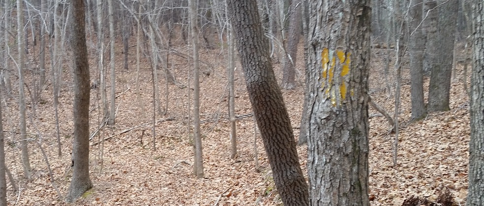
A few yards ahead a tree caught my attention. Something was odd about it. The texture of the bark consisted of flat ridges that looked they had been stretched apart. I think that's typical of poplar tree bark. At about eye-level, several of the flat ridges were pale yellow on top. The valleys between these yellow ridges were a normal bark-gray. A few of the ridges had pale yellow edges but the tops were gray. All of this odd coloring was limited to an area I could cover with two hands.
I stepped closer to get a better look. The yellow coloring was not lichen. This was paint.
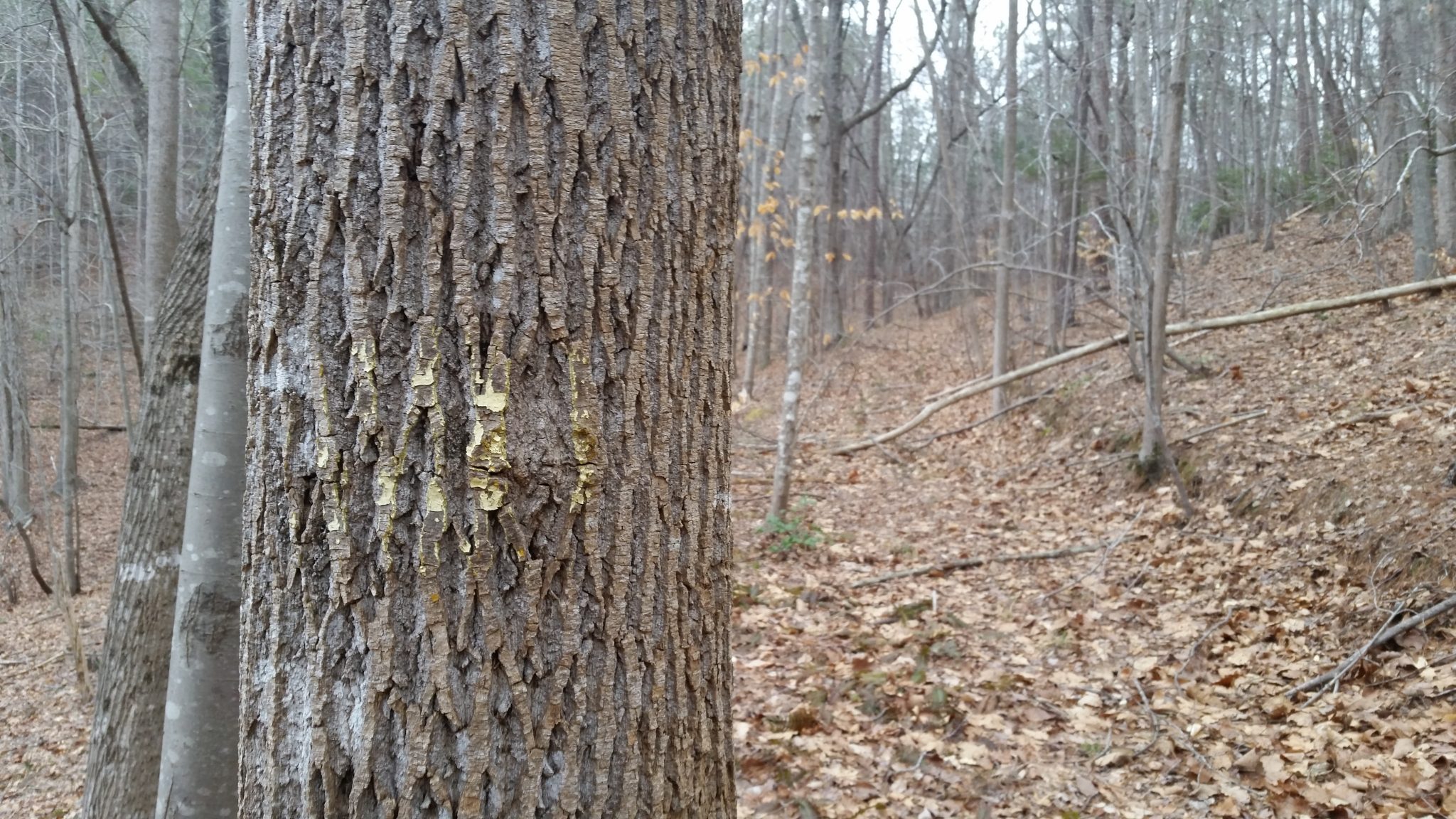
This was an old trail blaze!
I stepped to the other side of the tree.
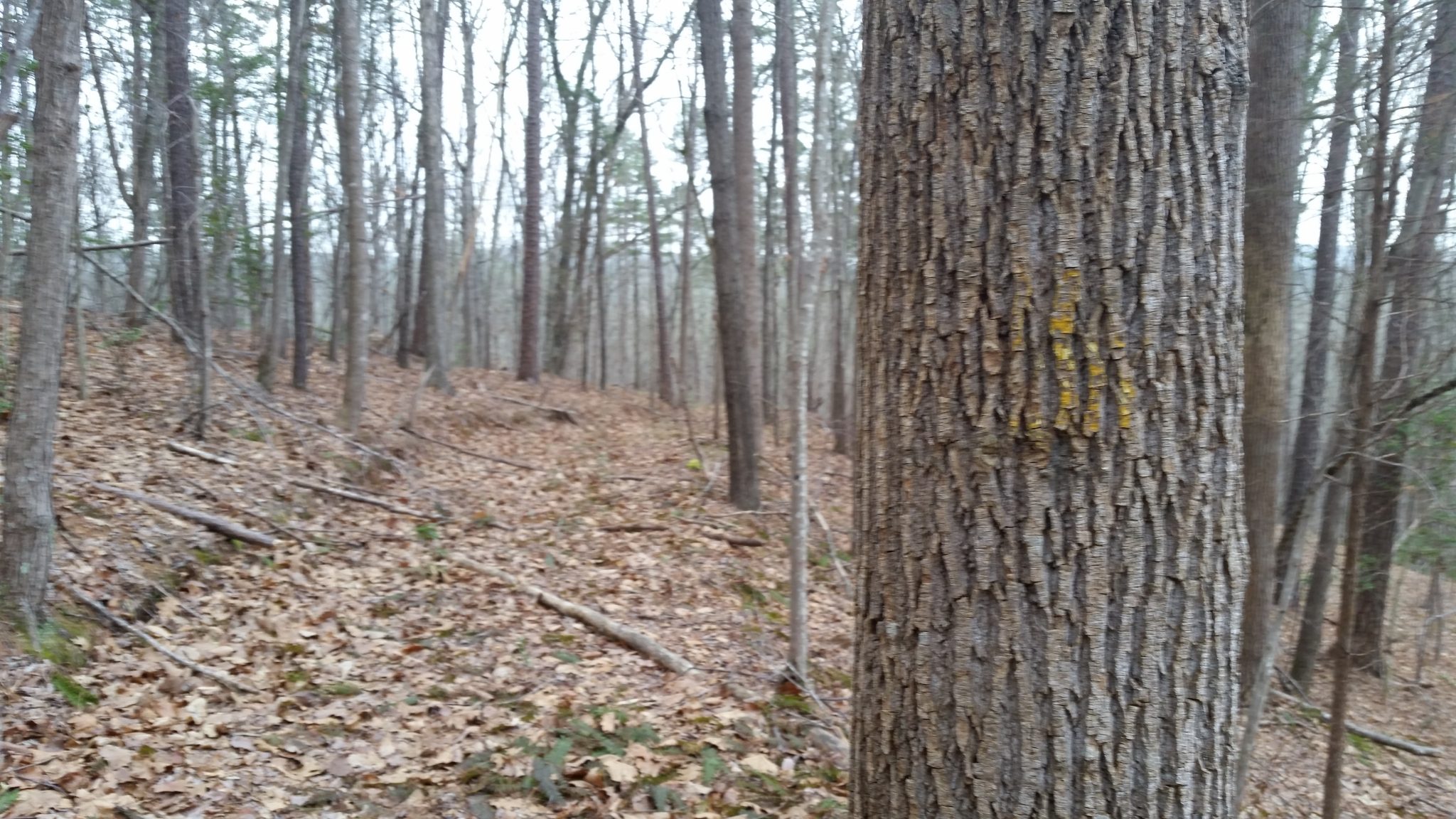
Yes! Another old blaze!
Now I was getting somewhere. This tree had obviously been blazed to guide travel in both directions.
Was this old roadbed a previous alignment of Camp Road? Or was it the lost trail?
I turned and looked up the roadbed for another blaze. But no blazes were in sight, so I resumed walking.
After another hundred feet I could see a fork in the roadbed ahead. The right side continued up along the spur ridge at a slightly steeper angle. The left side leveled off and curved across the bottom of the re-entrant.
My eyes were now in old-blaze mode, darting from tree to tree looking for a faint splash of faded, non-gray color.
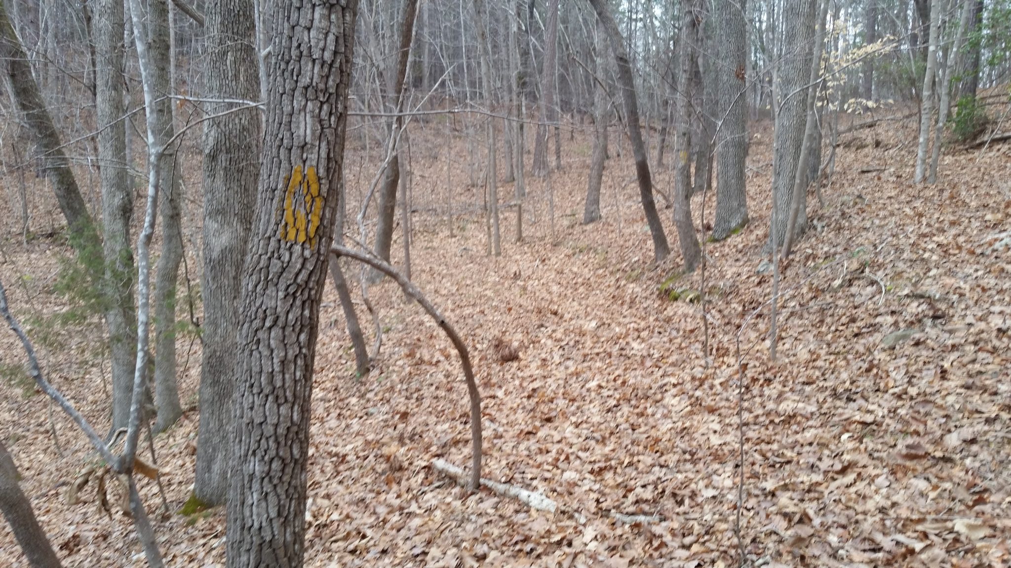
As I reached the fork, I was rewarded again. A tree on the left held a fairly-intact old yellow blaze. There was a blaze on the back side of this tree too.
Which of the two roadbeds did the blazed route follow from here?
I could almost see the saddle at the top of the ridge. I knew Camp Road ran through the saddle and that's where the right side appeared to be heading.
The left side curved across the reentrant. I could see enough of its sidehill cut from here to tell it led away from the saddle and out along the southwest ridge. The lost trail's dashed line lay on that ridge on the map.
With all due respect to Robert Frost, here were two roads diverged in a wood; one less traveled than the other, and I ... I took the left one. Not because it was less traveled (it wasn't) but because it led where I felt most likely to find more evidence of the lost trail.
A little past the fork, I spotted another old blaze. This tree was clearly on the left side of the fork. Unfortunately, there was no matching blaze on the back side of the tree. Or on the trees close to it.
But this single blaze confirmed that the blazed route did not head up to the saddle from the fork in the road.
I followed the left roadbed as it curved around to the other side of the re-entrant. It started angling downhill along the slope, and then the well-defined roadbed ended at some low mounds of earth and rock. The brushy undergrowth was heavier here. If I kept walking in the same direction, I would begin dropping downhill rapidly. Doing so would take me further away from the ridgeline above, where I suspected the lost trail to be.
No more old blazes were to be found around the end of the roadbed. The vegetation on this side of the re-entrant was different, containing more pines and small brush. I wasn't sure if the vegetation change was because this slope faced more east and the slope behind me faced more south, or if the difference might have been due to past timber cut activity.
I headed back towards the saddle to look around. A small ditch seemed to run from the end of the road back up to the saddle. If this was once a trail, it would have turned from the roadbed with a very sharp, steep switchback. It looked more like one of the many odd ditches that run along hillsides in the Uwharries than an old trail.
As I neared the saddle, the faint ditch disappeared under several mounds of earth and debris. These mounds were probably made when someone cleared off the area in the saddle, maybe for a logging operation loading deck. The other fork of the old roadbed also reached the saddle here and was covered by the mounds. I poked around the south side of the saddle but could not find any indication of a trail.
The forest growth on the ridge to the southwest of the saddle was mostly quick-growing pine. My guess is the timber on the ridge had been cut, loaded up here in the saddle, and hauled off the mountain. I feared the paint blazes I wanted to find were probably hauled away with those trees.
What should I look for next?
Many of the trails laid out in the 1970's followed old roadbeds. The old blazes I had just discovered were along an old roadbed. If there were no blazes to be found around the saddle, maybe I should just look for other old roadbeds. They should have survived a clear-cut.
There was no sign of a roadbed heading directly from the saddle along the southwest ridge, so I just started wandering through the trees in that general direction. The mapmaker's dashed line stayed below the ridgetop as it made its grin-shaped curve around to the hunt camp. Could that have been a detail described by his source of information? This guess was a bit of a stretch, but I was scrambling for clues to follow. I decided to stay below the ridgetop as I wandered.
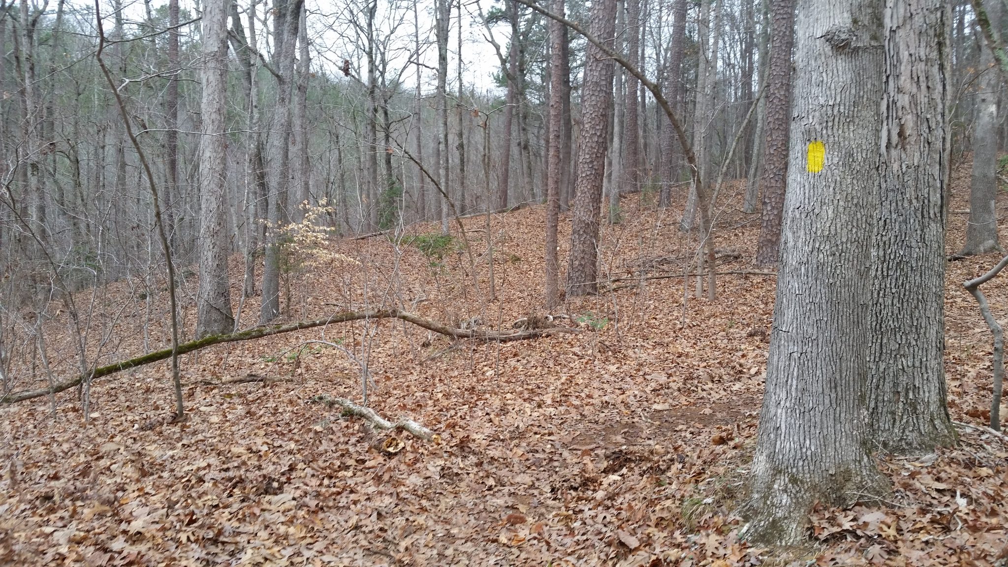
Within a few dozen yards of the saddle, I noticed a faint linear depression in the ground. The trees were fairly thick here, so I had to dodge and weave around branches as I tried to follow along. The depression slowly became more pronounced. It was leading me along the ridge where I wanted to go.
In another hundred feet, this old roadbed had become pretty obvious. The undergrowth on it thinned out and there was an obvious sidehill cut along the slope. The further I walked, the more open and well-defined the roadbed became. I still didn't see any more old blazes, even though there were a number of trees along the roadbed larger than the ones below with old blazes.
The further the old road went along the ridge, the higher it rose above the Spencer Creek valley. On the other side, I could see the ridge the Uwharrie Trail descends on its way north to Spencer Creek. Further to the south, Buck Mountain stood out with its communication towers.
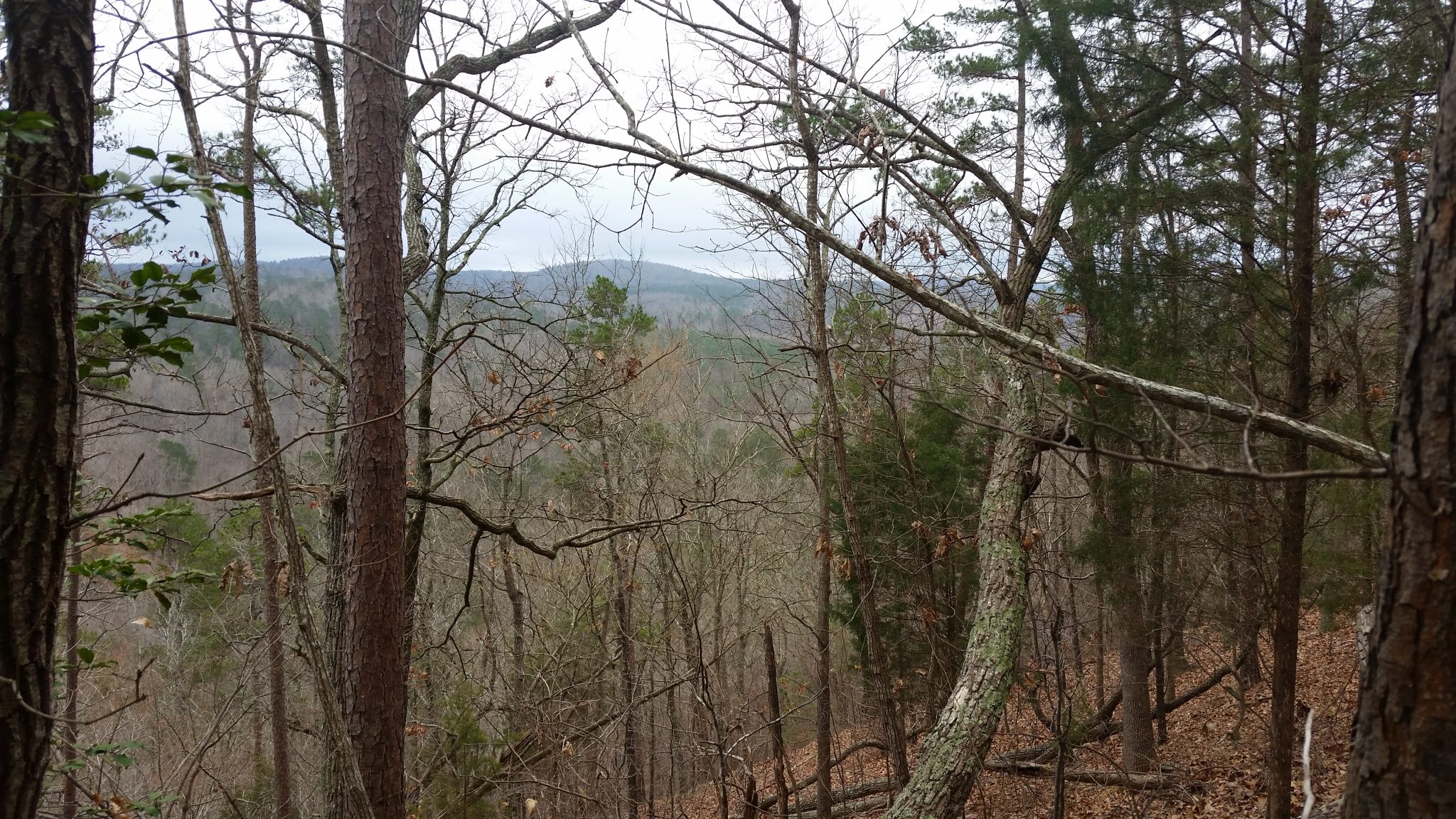
As this open roadbed neared the high point at the end of the ridge, it abruptly disappeared under a pile of rocks and debris. This must have been as far as the loggers needed to go to reach all the timber out on the ridge.
None of the trees around the end of the roadbed held any sign of old paint blazes. If this area was clear-cut after the trail was established, and the trail had indeed come this way, any blazes likely left with the logs. I seemed to be out of clues to follow, again.
What had I discovered so far?
I found several old blazes along an old roadbed that Tee's into Camp Road near the Uwharrie Trail. These details strongly support the idea that the mapmaker drew the lost trail's intersection with Camp Road backward. This junction could very well be the east end of the lost West Morris Mountain Trail.
This blazed roadbed leads from Camp Road toward the southwest ridge of Morris Mountain. While not solid evidence of the trail going around the southwest ridge, the blazed road is pointing in that direction.
I found another old roadbed running along the southwest ridge. I was not able to find any old blazes along this roadbed, but the area did appear to have been clear-cut.
Surprisingly enough, the old blazes and a good portion of the roadbed along the southwest ridge are located very close to the mapmaker's Cheshire-cat-grin dashed line on the map. I'll take this as a good sign that my search is on the right track.
Thanks, Abe!
What do you think?
Did you hike the West Morris Mountain Trail in the late 1970's or early 1980's before it was 'lost'? If so, I would love to hear about your memories of this trail.